The Frankenjura, in northern Bavaria, is where modern sport climbing grew up. Around 1,000 crags of pocketed Jurassic limestone and dolomite are scattered through the wooded valleys between Nuremberg, Bamberg and Bayreuth. Kurt Albert painted the first red dot (Rotpunkt), the origin of "redpoint", at the foot of the Streitberger Schild. Wolfgang Güllich climbed Wallstreet, the world's first 8c, on the Krottenseer Turm in 1987, and Action Directe, the first 9a, at the Waldkopf next door in 1991. Most climbers say spring and autumn are the best seasons, and many call October the best month. We used 25 years of weather data to check.
We replayed 25 years (2001–2025) of real daily observations from the Deutscher Wetterdienst (DWD), Germany's national weather service, through the climbingforecast drying model. Rain, temperature and humidity come from the DWD station at Gräfenberg-Kasberg (506 m), on the Jura plateau in the southern Frankenjura. That matters: the Jura is the first high ground storms meet on their way in from the south-west, and Gräfenberg gets one and a half to two times the rain of Nuremberg airport. Wind comes from the airport, because the Jura stations don't measure it. We ran the model for four crags: Weißenstein, the Krottenseer Turm, the Bärenschlucht and the Streitberger Schild. They came out within a few points of each other in most months, so the numbers below are their average. We scored every day twice: once for an early-morning session, and once for an afternoon session.
When is the best time to climb in the Frankenjura?
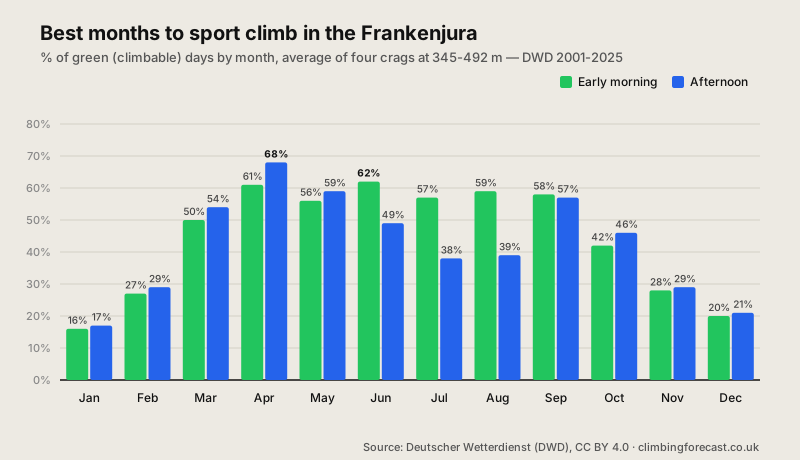
April is the best month. Scored for an afternoon session, April comes out on top at 68% green days, then May (59%) and September (57%). April is the driest month in the Frankenjura, at about 49 mm of rain on eight or nine wet days, and highs of about 15°C give good friction on the pockets. At Weißenstein, April reached 60% or more in 19 of the 25 years.
May and September are the next best. May gets more rain than April, about 85 mm, but warm days dry the rock quickly. September has the fewest wet days of any month apart from April, and highs of about 19°C.
In summer, start early. Scored for an early-morning session, June (62%), August (59%), September (58%) and July (57%) are as good as anything in spring. In the afternoon, the heat drags July and August down to 38–39%.
October is good, but it isn't the best. At 46% in the afternoon, it's behind April, May, September and even March. See below for why.
Winter is mostly off. From December to February, only 16–29% of days are green.
Frankenjura climbing conditions month by month
| Month | Morning | Afternoon | High | Rain |
|---|---|---|---|---|
| Jan | 16% | 17% | 3°C | 87 mm |
| Feb | 27% | 29% | 5°C | 70 mm |
| Mar | 50% | 54% | 9°C | 64 mm |
| Apr ★ | 61% | 68% | 15°C | 49 mm |
| May | 56% | 59% | 19°C | 85 mm |
| Jun | 62% | 49% | 23°C | 71 mm |
| Jul | 57% | 38% | 25°C | 89 mm |
| Aug | 59% | 39% | 24°C | 83 mm |
| Sep | 58% | 57% | 19°C | 79 mm |
| Oct | 42% | 46% | 14°C | 72 mm |
| Nov | 28% | 29% | 8°C | 80 mm |
| Dec | 20% | 21% | 4°C | 87 mm |
Average of Weißenstein, Krottenseer Turm, Bärenschlucht and Streitberger Schild (345–492 m), 25 years (2001–2025) of real daily observations from the Deutscher Wetterdienst station at Gräfenberg-Kasberg (506 m), with wind from Nürnberg. Morning and Afternoon are the % of green (climbable) days, scored at the day's low and at the day's high. High is the average daily high at Weißenstein; Rain is the monthly average at Gräfenberg-Kasberg. Factors in rain, drying time, wind, humidity, snow and heat. Cold, dry days count as green. Source: Deutscher Wetterdienst (DWD), CC BY 4.0.
Isn't October the best month in the Frankenjura?
Many climbers say so, and on a crisp, sunny October day the friction is superb. But over 25 years it scores 46% in the afternoon and 42% in the morning, well behind April. April beat October in 20 of the 25 years in our replay, and October reached 60% in only 4 of them.
It isn't the rain itself. October gets about 72 mm on 11 wet days, about the same as May. The difference is how fast the rock dries afterwards. In October, the air averages 87% humidity, highs fall to about 14°C, and the days are short, so the rock dries slowly. After a wet day, the model's drying time in October is about 45 hours, against about 30 in summer. Most Frankenjura crags sit in forest, where the air stays damp for longer still. A single wet day in October often costs you two days of climbing.
So October is still worth a trip. Pick steep, open crags that shed water quickly, and keep a rest day in hand. If you can choose, go in April or September.
Can you climb in the Frankenjura in summer?
Yes, but start early. At the crags, July and August highs average about 24–25°C, and a high of 27°C or more, the point where our model starts to flag the heat, happens on about nine or ten days in each month. That's what drags summer afternoons down to 38–39%. Scored at the day's low instead, for an early-morning session, June scores 62%, and July and August 57–59%.
The forest helps. Most Frankenjura crags sit among trees, many of them in deep, shady valleys, so there's usually somewhere in the shade. Summer is also the wettest time of year: July is the wettest month at Gräfenberg, at about 89 mm, much of it from afternoon thunderstorms, and climbers who know the area warn that August can feel sticky and humid under the trees. In midsummer, climb in the morning, choose shady crags, and keep an eye on the sky after lunch.
Bird closures: check before a spring trip
Spring has the best weather of the year, but it's also nesting season. In the Northern Frankenjura, crags used by nesting peregrine falcons are closed from February to June, and crags used by eagle owls from January to July. Some crags also have closures for jackdaws. Climbers and conservationists agreed the closures together, and they've worked: the LBV says the cooperation is a big part of why both birds are no longer on the red list of endangered species.
Closures are signed at the crag, and the current list is published by IG Klettern. If the birds don't nest at a crag, the Bavarian bird protection society LBV reopens it early, often in spring. With around 1,000 crags there's always somewhere else to climb, but check the list before you plan an April or May trip around a particular crag.
Can you climb in the Frankenjura in winter?
Not often. From December to February, only 16–29% of days are green. Highs average 3–5°C, it rains or snows on 11 to 14 days a month, and snow lies on the ground on about 8 to 14 days a month. On a dry, sunny day, a south-facing crag can be climbable, and many locals go bouldering instead. March improves quickly, to 54% in the afternoon, as the snow goes and the days get longer.
Peak Potential
April leads at 68% green days. It's the driest month of the year, with cool highs around 15°C.
Spring Closures
Peregrine and eagle owl crags are closed from early in the year to June or July. Check the IG Klettern list first.
Slow Autumn
October is 46% green. The air is cool and damp, so the rock takes almost two days to dry after rain.
How we calculated this
We ran 25 years (2001–2025) of daily weather from the Deutscher Wetterdienst through the drying model behind the live Weißenstein forecast. Rain, temperature and humidity come from the DWD station at Gräfenberg-Kasberg (506 m), and wind from Nürnberg airport. We adjusted the temperature to each crag's height, and tracked the snow building up and melting from day to day. Each day is rated on recent rain, drying time, wind, humidity, snow and heat, once at the day's low, for an early-morning session, and once at the day's high, for an afternoon session. Cold, dry days count as green. The model doesn't know which crags are in the shade, so the summer afternoon numbers are a little worse than the reality on shady crags.
Data retrieved 3 October 2026 from the DWD Climate Data Center (stations 01721 Gräfenberg-Kasberg, 03668 Nürnberg and 00320 Heinersreuth-Vollhof). Source: Deutscher Wetterdienst (DWD), licensed under CC BY 4.0.
It won't replace checking the forecast the week you go, but it's an honest answer to "when should I book?". Before you go, check the live Weißenstein, Krottenseer Turm, Bärenschlucht and Streitberger Schild forecasts. For more European limestone, see our Céüse and Gorges du Tarn articles.
Good luck and enjoy the climbing!