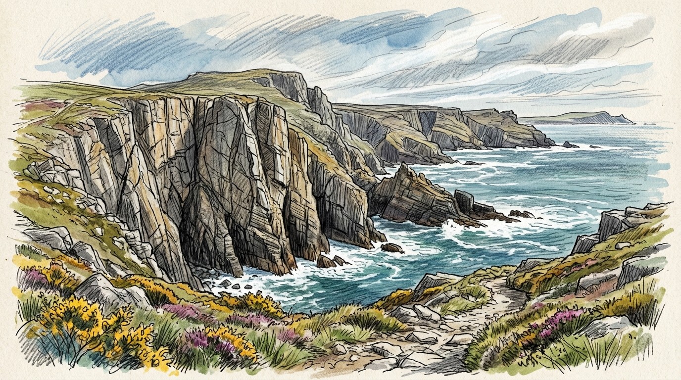
Pembroke, on the south coast of Pembrokeshire in west Wales, is Britain's great sea-cliff limestone area: miles of steep, solid cliffs, zawns and stacks above the sea, with thousands of trad routes, many of them only reached by abseil. It's on the edge of the Atlantic, so the weather is mild but changeable, and the climbing calendar also depends on tides, nesting seabirds and an army firing range. We ran 30 years of weather through our drying model to find out when the rock is most often dry and climbable.
We took 30 years (1996–2025) of daily weather from the Met Office's weather stations at Milford Haven (temperature, humidity and wind), 14 km from the cliffs, and Orielton (rain), 6 km from St Govan's Head. Then we ran every day through the climbingforecast drying model, with the same limestone rules as our live forecasts. Each day is scored for an afternoon session, and again at the day's low for an early start. The model covers the weather only: tides, bird restrictions and firing on the ranges are up to you.
When is the best time to climb in Pembroke?
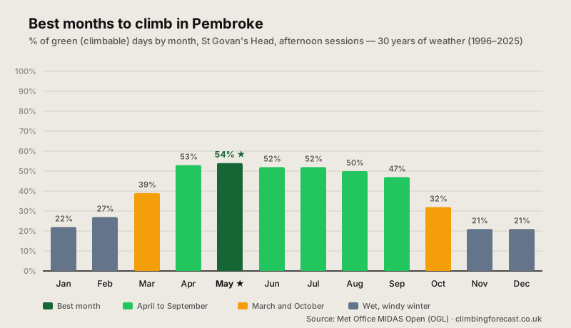
April to September, for the weather. St Govan's Head scores 47–54% green afternoons through the whole season: May is best at 54%, just ahead of April (53%), June and July (52%) and August (50%). The best weeks are the second half of April, the first half of May and the first half of June, all at 56%. The differences between these months are small; the weather on the day matters much more than the month.
But the birds decide which crags are open. Many Pembroke crags have seabird nesting restrictions from 1 March to 1 August, and some of the stacks until mid-August. In spring and early summer you can still climb, but on fewer crags. From August, the restrictions lift, the sea is at its warmest and the weather is still good, which is why August and September are many climbers' favourite time.
Why the scores look low. Pembroke gets showers all year: even in summer it rains on about 10 days a month. And the air off the sea is humid, so on still, muggy days the limestone feels greasy and our model marks it amber. That keeps every month below 60%. These scores don't compare directly with those of inland crags; on a dry, breezy day, Pembroke rock is superb.
Pembroke climbing conditions month by month
| Month | Afternoon | Morning | High | Rain | Rain Days |
|---|---|---|---|---|---|
| Jan | 22% | 20% | 9°C / 47°F | 112 mm | 15.9 |
| Feb | 27% | 25% | 9°C / 48°F | 82 mm | 12.7 |
| Mar | 39% | 36% | 10°C / 51°F | 81 mm | 12.0 |
| Apr | 53% | 50% | 13°C / 55°F | 68 mm | 10.6 |
| May ★ | 54% | 52% | 16°C / 60°F | 66 mm | 9.8 |
| Jun | 52% | 49% | 18°C / 64°F | 73 mm | 10.3 |
| Jul | 52% | 52% | 20°C / 67°F | 75 mm | 10.6 |
| Aug | 50% | 48% | 19°C / 67°F | 94 mm | 12.6 |
| Sep | 47% | 45% | 18°C / 64°F | 88 mm | 11.8 |
| Oct | 32% | 30% | 15°C / 59°F | 132 mm | 15.7 |
| Nov | 21% | 18% | 12°C / 53°F | 147 mm | 18.5 |
| Dec | 21% | 18% | 9°C / 49°F | 132 mm | 17.2 |
St Govan's Head (35 m), 30 years (1996–2025) of real daily observations from the Met Office: temperature, humidity and wind at Milford Haven, rain at Orielton. Afternoon and Morning are the % of green (climbable) days, scored at the day's high and at the day's low. High is the average daily high, Rain the monthly average, and Rain Days the days with 1 mm or more. Factors in rain, drying time, wind, humidity, snow and heat; not tides, bird restrictions or range firing. Contains public sector information licensed under the Open Government Licence v3.0.
Bird restrictions, tides and the ranges
Seabird restrictions. Pembroke's cliffs are home to nesting seabirds, and many crags, or parts of them, are closed to climbing from 1 March to 1 August; some stacks and headlands stay closed until mid-August. The restrictions vary from year to year and from crag to crag, so check the BMC's Regional Access Database and the local signs before you climb. Each of our crag pages lists its restriction dates.
The firing ranges. The coast from St Govan's to Stack Rocks (Range East) is part of the army's Castlemartin firing range. You can climb there when there's no firing, which is normally at weekends, on bank holidays and in the evenings, and in recent years for all of August. Range West needs an annual briefing. Check the range's 24-hour information line, (01646) 662367, before you go.
Tides and swell. Many routes start from platforms near the sea, and some can only be reached at low tide or in a calm sea. Check the tide times and the swell, and know your escape route before you abseil in.
Can you climb in Pembroke in winter?
Sometimes, on the sunny side. Pembroke's coast is mild: it rarely freezes, with highs of about 9°C (48°F) even in midwinter. But November to January are the wettest months, with 110–150 mm of rain on 16 to 19 days a month, and the winter gales bring big seas. Scores fall to 21–27%. A calm, dry spell can still give great days on the south-facing crags, which catch the low winter sun, and the bird restrictions don't apply.
Trad climbing in Pembroke: what to expect
Steep sea-cliff limestone. Pembroke's climbing is trad on solid Carboniferous limestone, from easy slabs to some of Britain's hardest sea-cliff routes, mostly one or two pitches. Many crags are reached by abseil, so carry prusiks and a spare rope, and leave the abseil rope in place if it's your way out. Bring a full rack of nuts and cams.
Read the conditions. Sea-cliff limestone can feel greasy on humid days and near the sea, and lower ledges can be soaked by spray in a big swell. South-facing crags like St Govan's Head and Saddle Head dry fastest in the sun and breeze.
Best: April to September
47–54% green afternoons all season. May is best, at 54%, but the differences are small.
Birds Until August
Many crags are closed for nesting seabirds from 1 March to 1 August. August and September have the most crags open.
Wet Winter
110–150 mm of rain a month from November to January, and winter gales. Scores fall to 21–27%.
How we calculated this
We used the Met Office's MIDAS weather station records, downloaded from the CEDA Archive. Temperature, humidity and wind come from Milford Haven (44 m), on the Milford Haven waterway 14 km north-west of St Govan's, the nearest coastal station with all 30 years; rain comes from Orielton, 6 km north of St Govan's, with a few gaps filled from Tenby. Orielton's own temperatures (to 2020), used as a check, give results within 7 points every month, and replacing the station's wind with a steady breeze changes them by 5 points or less.
Every day is rated on recent rain, drying time, wind, humidity, snow and heat, at the day's high (afternoon) and low (morning). The model reads the air temperature, not the rock, and it doesn't know about tides, swell, spray, bird restrictions or firing, so use the numbers to choose your month and the live St Govan's forecast to choose your day.
Data retrieved 8 October 2026. Contains public sector information licensed under the Open Government Licence v3.0: Met Office (2026), MIDAS Open: UK Land Surface Stations Data, NCAS British Atmospheric Data Centre (stations 01215 Milford Haven Conservancy Board, 01217 Orielton, 01222 Tenby). Access information from the BMC Regional Access Database. For more UK climbing, see our Peak District guide; for granite sea cliffs abroad, Bohuslän and Lofoten.
Good luck and enjoy the climbing!