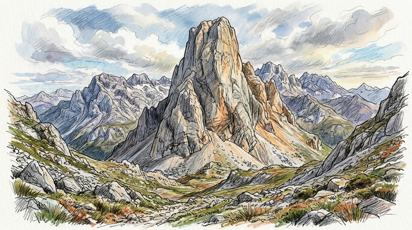
The Naranjo de Bulnes, or Picu Urriellu, is the most famous rock tower in Spain: a 2,519 m block of limestone in the middle of the Picos de Europa, with walls up to about 550 m high. It's a big, serious alpine climb, a long walk from the road, and it stands only about 20 km from the Atlantic, so the weather is famously fickle. We ran 30 years of weather through our drying model to find out when the rock is most often dry and climbable.
We took 30 years (1993–2022) of daily rain and temperature from AEMET, Spain's national weather service, from its 5 km grid at the cell that contains the tower, and moved the temperatures to 2,000 m, the height of the foot of the big faces by the Vega de Urriellu hut. Then we ran every day through the climbingforecast drying model, with the same limestone rules as our live Naranjo de Bulnes forecast. Each day is scored for an afternoon session, and again at the day's low for an early start.
When is the best time to climb the Naranjo de Bulnes?
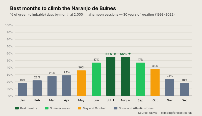
Summer: July and August are best. Both score 55% green afternoons, with June and September at 47%. The best fortnight of the year is the second half of July, at 60%. Summer is the driest season in the Picos: July gets about 50 mm of rain and August 56 mm, against 172 mm in January. At 2,000 m, summer highs average a cool 18–19°C (65–66°F), so heat is never the problem.
Why the scores look low. Even in summer, rain falls on about 9 or 10 days a month, as weather comes in off the Atlantic. And limestone dries slowly: our model gives it most of a day after rain, and longer on walls that seep, so each wet day costs more than one day of climbing. That's what keeps even the best months near 55%. These scores don't compare directly with those of granite crags.
Wait for a settled spell. Every summer is different. August has scored up to 77% green in a dry year and as low as 16% in a wet one. The best plan is a flexible one: watch the forecast, and go up when a few days of high pressure are on the way.
Naranjo de Bulnes climbing conditions month by month
| Month | Afternoon | Morning | High | Rain | Rain Days |
|---|---|---|---|---|---|
| Jan | 18% | 17% | 5°C / 40°F | 172 mm | 16.7 |
| Feb | 22% | 21% | 5°C / 42°F | 158 mm | 14.0 |
| Mar | 28% | 26% | 7°C / 45°F | 139 mm | 14.9 |
| Apr | 29% | 26% | 9°C / 47°F | 129 mm | 16.2 |
| May | 36% | 32% | 12°C / 54°F | 109 mm | 15.8 |
| Jun | 47% | 43% | 17°C / 62°F | 85 mm | 11.5 |
| Jul ★ | 55% | 51% | 19°C / 65°F | 50 mm | 9.4 |
| Aug ★ | 55% | 52% | 19°C / 66°F | 56 mm | 9.6 |
| Sep | 47% | 44% | 16°C / 60°F | 90 mm | 11.4 |
| Oct | 38% | 35% | 12°C / 54°F | 146 mm | 14.1 |
| Nov | 24% | 22% | 8°C / 46°F | 219 mm | 17.2 |
| Dec | 18% | 17% | 5°C / 42°F | 172 mm | 16.4 |
Naranjo de Bulnes at 2,000 m (the foot of the big faces), 30 years (1993–2022) of AEMET's daily 5 km grids of observed rain and temperature, at the grid cell that contains the tower, with temperatures moved to 2,000 m. Afternoon and Morning are the % of green (climbable) days, scored at the day's high and at the day's low. High is the average daily high, Rain the monthly average (rain and melted snow), and Rain Days the days with 1 mm or more. Factors in rain, drying time, humidity, snow and heat. Cold, dry days count as green. Información elaborada utilizando, entre otras, la obtenida de la Agencia Estatal de Meteorología.
Climbing the Naranjo de Bulnes in summer
June to September is the season. June and September score 47%, July and August 55%. June can still have snow patches on the approach and in the gullies after a snowy winter, and September's days are shorter, but both are quieter than the summer holidays.
Mornings aren't better. Unlike in hot, dry climbing areas, early starts don't score better here: mornings come out 3–4 points lower than afternoons, because the rock has had less time to dry. Start early anyway for the long routes, to be off the tower before any afternoon cloud or storm builds.
Watch for cloud. The Picos are known for their sea of cloud: damp Atlantic air often fills the valleys while the peaks stand above it in sunshine, but on other days the cloud sits on the tower itself and wets the rock. Check a mountain forecast for the cloud base, not just the rain.
Autumn, winter and spring
From November to April, it's snowy and wet. Scores fall to 18–29%. November is the wettest month, at 219 mm on about 17 days, and from December to April snow lies at the foot of the tower on 10 to 19 days a month in our replay. In winter the Naranjo is a mountaineering objective, not a rock climb.
May and October are shoulder months. May scores 36% and October 38%. A settled spell can give good climbing, but expect snow on the approach in May, short days and cold rock in October.
Climbing the Naranjo de Bulnes: what to expect
A big, serious tower. The Naranjo's west face is about 550 m high, and every way up is a proper climb: there is no walking route to the summit. It was first climbed on 5 August 1904, by Pedro Pidal and the shepherd Gregorio Pérez, "El Cainejo", by the north face. The great west face was first climbed in 1962, by Alberto Rabadá and Ernesto Navarro.
The south face is the usual way up. It's the sunniest side, the quickest to dry, and holds the easiest and most popular routes. The west and north faces get less sun and seep for longer, so save them for a settled spell. The descent is by abseil, and the rock on the descent is loose in places.
Getting there. The usual approach is on foot from Sotres via the Collado de Pandébano, or from Bulnes, to the Vega de Urriellu hut at about 1,960 m at the foot of the west face. Allow a few hours. The hut is the base for most climbs, and booking ahead in summer is wise.
Best: July and August
55% green afternoons. The second half of July is the best fortnight, at 60%.
Slow-Drying Limestone
Rain falls on 9 or 10 days a month even in summer. Wait for a settled spell, and start with the sunny south face.
Winter Snow
From November to April, scores fall to 18–29%, with snow at the foot of the tower and the wettest weather of the year.
How we calculated this
AEMET has a weather station at the Vega de Urriellu hut, but its daily records aren't freely downloadable, and it publishes no long-term averages for any high station in the Picos. So we used AEMET's daily 5 km grids of observed rain and maximum and minimum temperature, which it builds from every station in its climate database. The cell we used contains the tower and averages about 2,150 m in height, and the grid's temperatures follow the terrain, so we moved them down 150 m to 2,000 m. The grids have no humidity or wind: we estimated the humidity from each day's low temperature (on cloudy, damp days the air is close to its dew point all day) and used a steady, moderate breeze. Rain from the 3 × 3 cells around the tower, a drier estimate of the humidity, and a smaller temperature adjustment each change the results by 3 points or less.
Every day is rated on recent rain, limestone drying time, humidity, snow and heat, at the day's high (afternoon) and low (morning), and the snow is carried from one day to the next. A 5 km grid smooths out the mountain, so it may miss some of the heaviest local showers, and the model doesn't know which face you're on, so use the numbers to choose your month and the live forecast to choose your days.
Data retrieved 8 October 2026. Información elaborada utilizando, entre otras, la obtenida de la Agencia Estatal de Meteorología (AEMET): daily 5 km grids of precipitation (version 2) and maximum and minimum temperature, 1993–2022; reference Peral, C., Navascués, B. and Ramos, P. (2017), Nota técnica 24, AEMET. Cell height from the SRTM terrain model (NASA / USGS). History from Wikipedia; hut and approach from Turismo Asturias. For more trad and big walls, see our Chamonix and Yosemite Valley guides; for other Spanish climbing, La Pedriza and Rodellar.
Good luck and enjoy the climbing!